
Landscapes were drawn by hand long before they were mapped by computer. The mellow palette, the small tufts and crowns and the calm outlines of the UrbanSens style are not an invention; they are a selection from a tradition that began in the garden plans and survey offices of the early nineteenth century, several of them in Munich, where UrbanSens works.
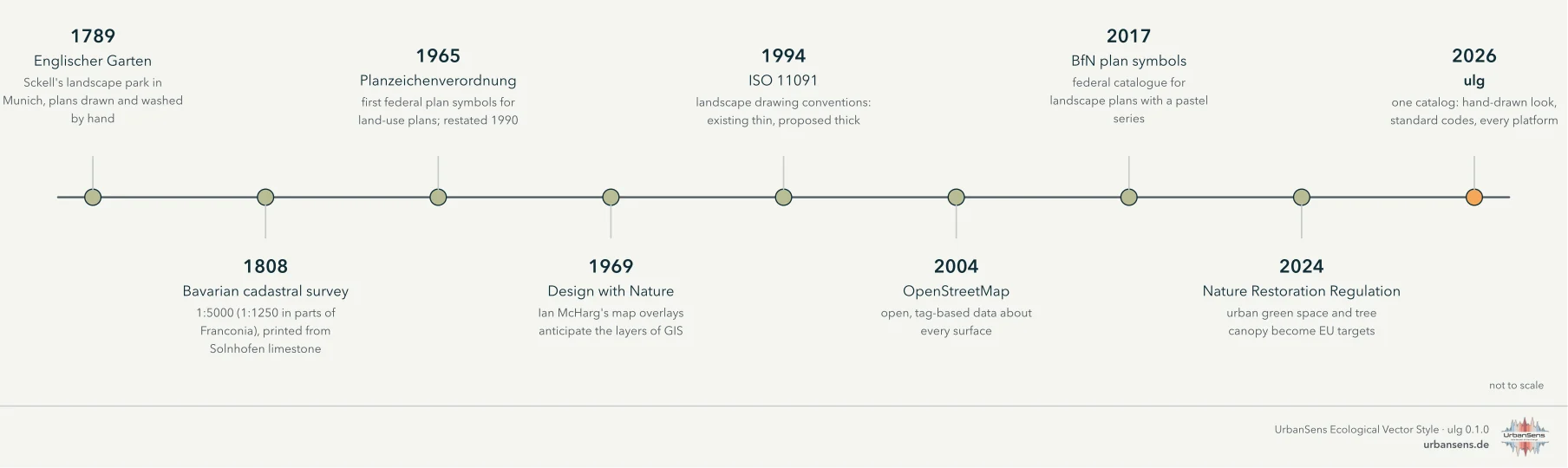
1.1 A park painted in green: Munich, 1789–1806#
In August 1789 Elector Karl Theodor decreed a public park along the Isar in Munich, at the initiative of Benjamin Thompson, later Count Rumford. Friedrich Ludwig von Sckell shaped it as a landscape garden; it opened in 1792 and, at 3.75 km², is one of the largest city parks in the world: the Englischer Garten. Sckell directed Munich's court gardens from 1804 until his death in 1823.


Look at the colours of this sheet: pale greens for the meadows, a deeper green for woods, clear blue for water, brick red for roofs, all on warm paper. Two hundred and twenty years later the UrbanSens palette uses the same relations: light, low-chroma fills, darker marks of the same hue, saturated colour only where something needs attention.


1.2 Stone, ink and the survey: the Bavarian Uraufnahme, 1808–1864#
In the 1790s Alois Senefelder found that a smooth slab of Solnhofen limestone, drawn on with greasy ink and wetted, would print: lithography. From 1809 he served as inspector of the royal lithographic institute in Munich, and the Bavarian survey took up the new technique early.
In 1808 Bavaria began the Uraufnahme, the first complete survey of every parcel in the kingdom, for the land tax. Surveyors worked at 1:5 000, at 1:2 500 for villages and in parts of Franconia even at 1:1 250. More than 23 000 sheets were drawn, engraved on limestone plates and printed; the stones are still kept by the Bavarian surveying office (LDBV).


The surveyors did not choose their marks freely. The 1808 instruction for the tax survey prescribed a sign for every kind of ground, and it reads like the first draft of a texture catalog:

Deciduous and coniferous woods, bushes, meadows, mossy meadows, pastures and waste ground, moss, gardens,
vineyards and hop gardens each have their own small mark; buildings, boundaries, paths, rivers and
bridges their own line. Replace Wiesen with meadow, Waldungen · Laubholz with
woodland_deciduous and Gärten with garden, and this page becomes a legend of the catalog in
chapter 3.
1.3 Crowns, tufts and washes: the language of garden plans#
Landscape architects drew with the same means. In Peter Joseph Lenné's plan for the Berlin Tiergarten the woods are built out of thousands of small crowns, the open lawns keep the paper tone and the paths are left white.


Rural maps followed conventions every reader knew. The archive description of this manuscript map from Württemberg lists them: houses red, fields brown, vineyards with vine symbols, meadows green, woods as tree symbols, paths brown, the rivers blue ("drawn by eye and freehand").

der nach dem Aug und freier Faust ist gezeichnet worden
end of the title of the Enzberg plan, Landesarchiv Baden-Württemberg, Hauptstaatsarchiv Stuttgart N 3 Nr. 47 (in English: which was drawn by eye and freehand)
Three habits of these drawings became rules of the style: marks are made by hand but placed with care (the wobble never hides the true edge); texture says what a surface is (crowns for trees, tufts for meadow, waves for water); and colour stays quiet so that the plan can carry a message.
1.4 From colour words to codes: the twentieth century#
Planning law turned conventions into rules. The German Planzeichenverordnung (PlanZV) first set federal plan symbols for land-use and zoning plans on 19 January 1965; the current version dates from 18 December 1990 and was last amended on 12 August 2025. It names its colours only in words (Grün mittel, Blau mittel) and gives one of the most useful rules for vegetation symbols: an open centre marks a tree to be planted, a filled centre a tree to be preserved (No. 13.2).
Die Planzeichen sollen in Farbton, Strichstärke und Dichte den Planunterlagen so angepaßt werden, daß deren Inhalt erkennbar bleibt.
Planzeichenverordnung 1990, § 2 Abs. 3 (in English: the symbols are to be adapted in hue, line weight and density to the base map so that its content stays recognisable)
In 1969 Ian McHarg's Design with Nature laid transparent maps of soils, water, slopes and vegetation on top of one another to find where building would do least harm: the layered map that geographic information systems made routine. The international standard for landscape drawings, ISO 11091 (1994), fixed how plans tell existing from proposed: thin lines for what is there, thick lines for what is planned. The cadastre went digital with the ALKIS model of the German surveying authorities, its object types and its signature catalogue.
1.5 Open data and ecological targets: the twenty-first century#
Since 2004 OpenStreetMap has described the surface of the world in open tags (landuse=meadow,
surface=gravel, natural=tree), and its Carto style made them a common visual language. In 2017 the
Federal Agency for Nature Conservation (BfN) published a catalogue of plan symbols for landscape
plans: light tints without outlines for areas of low to moderate value, saturated colours with a black
outline for areas of high value, and brown vertical dashes for fallow. This style adopts that
convention.
In 2024 the EU Nature Restoration Regulation (2024/1991) made urban green space and tree canopy a legal target: no net loss by 2030 compared with 2024, and an increasing trend from 2031, measured with Copernicus data. What a map shows as green is now also what a city reports.
By 31 December 2030, Member States shall ensure that there is no net loss in the total national area of urban green space and of urban tree canopy cover in urban ecosystem areas […] compared to 2024.
Regulation (EU) 2024/1991 (Nature Restoration Regulation), Article 8(1)
1.6 2026: one catalog#
UrbanSens set out the visual language it wanted for its maps on one sheet: habitat types and surface materials in a clean, mellow, lightly hand-drawn vector style that works at every scale.
A clean, consistent and scalable visual language to represent nature, surfaces and biodiversity in a professional, architectural style, using simple vector patterns and symbols.
UrbanSens, reference sheet of the Ecological Vector Style
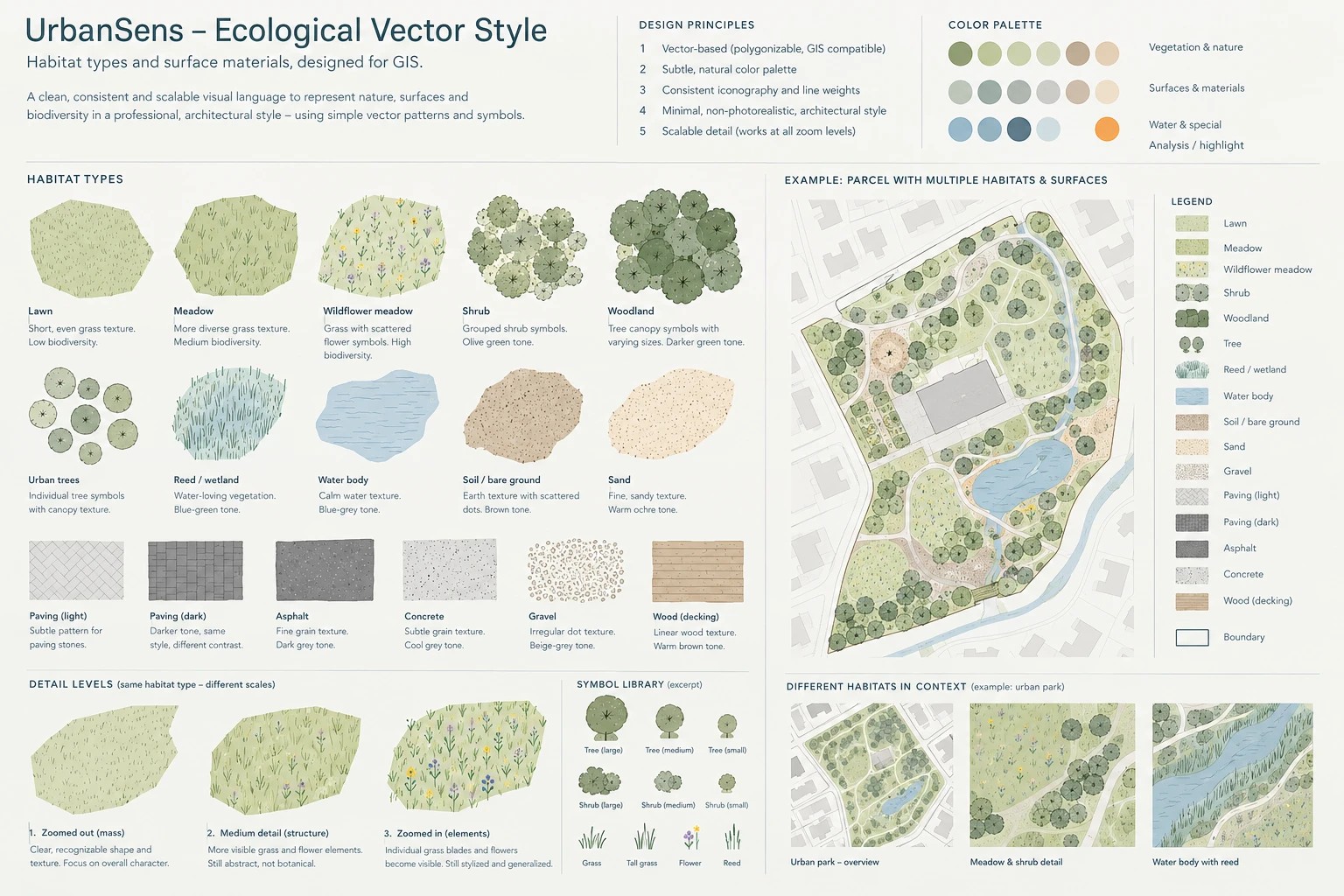 |
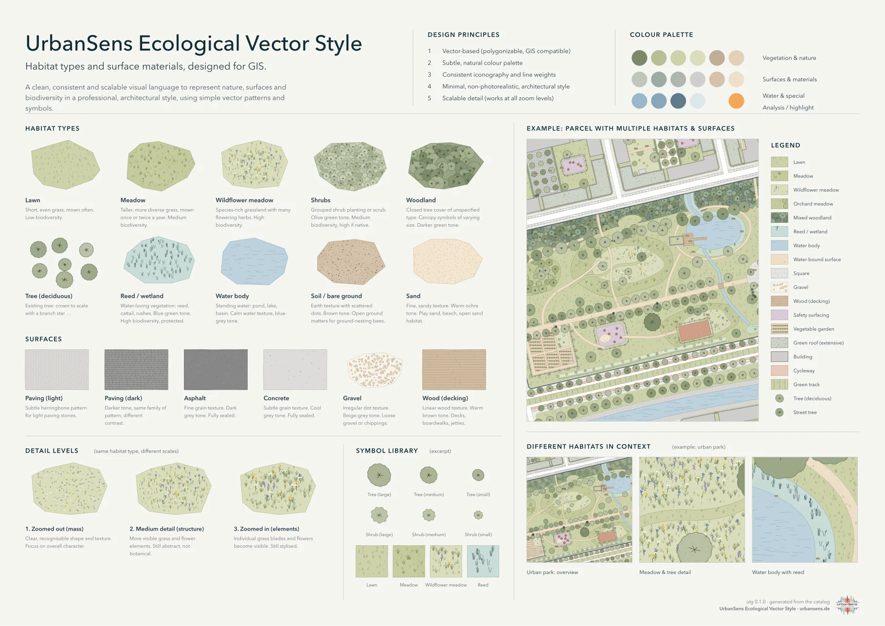 |
| The brief: the UrbanSens reference sheet for the Ecological Vector Style. | The result: the same sheet, generated by ulg sheet from the catalog. |
ulg turns that sheet into a library. It keeps the look (quiet colours, textures that say what a
surface is, trees drawn to scale) and ties every element to the conventions this chapter traced:
the codes of ALKIS, XPlanung, the biotope lists and OpenStreetMap, the status symbols of PlanZV and
ISO 11091, the coefficients planners report, and the official colours of each convention when a map
has to follow them.
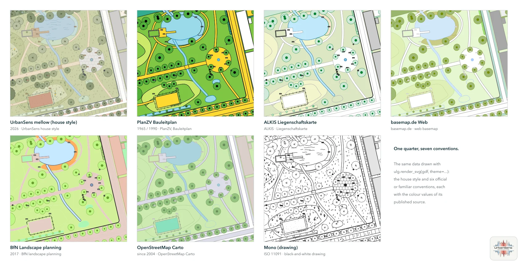
Image credits#
| Image | Author, date | Licence | Source |
|---|---|---|---|
| Plan of the Englischer Garten (detail) | Königlich bayerische Direction des Topographischen Bureaus, 1806 | public domain | Commons |
| Monopteros, Englischer Garten | Julian Herzog, 2014 | CC BY 4.0 | Commons |
| Lithographic stone and print | Chris 73, 2006 | CC BY-SA 3.0 | Commons |
| Drawing rules of the Bavarian tax survey | Königlich Bayerisches Vermessungsamt, c. 1840 | public domain | Commons |
| Tiergarten plan | Peter Joseph Lenné (design), Gerhard Koeber (drawing), 1835; Landesarchiv Berlin | public domain | Commons |
| Plan of the Enzberg hunting district | unknown, undated; Landesarchiv Baden-Württemberg, HStA Stuttgart N 3 Nr. 47 | CC BY 4.0 | Commons |
| Timeline, reference sheet, style sheet, conventions | UrbanSens / generated with ulg |
none | this repository |
The historical images are linked from Wikimedia Commons, not copied into the repository; they need an internet connection to display.